

CultiWise Introduces drone-derived prescription maps for precision spraying

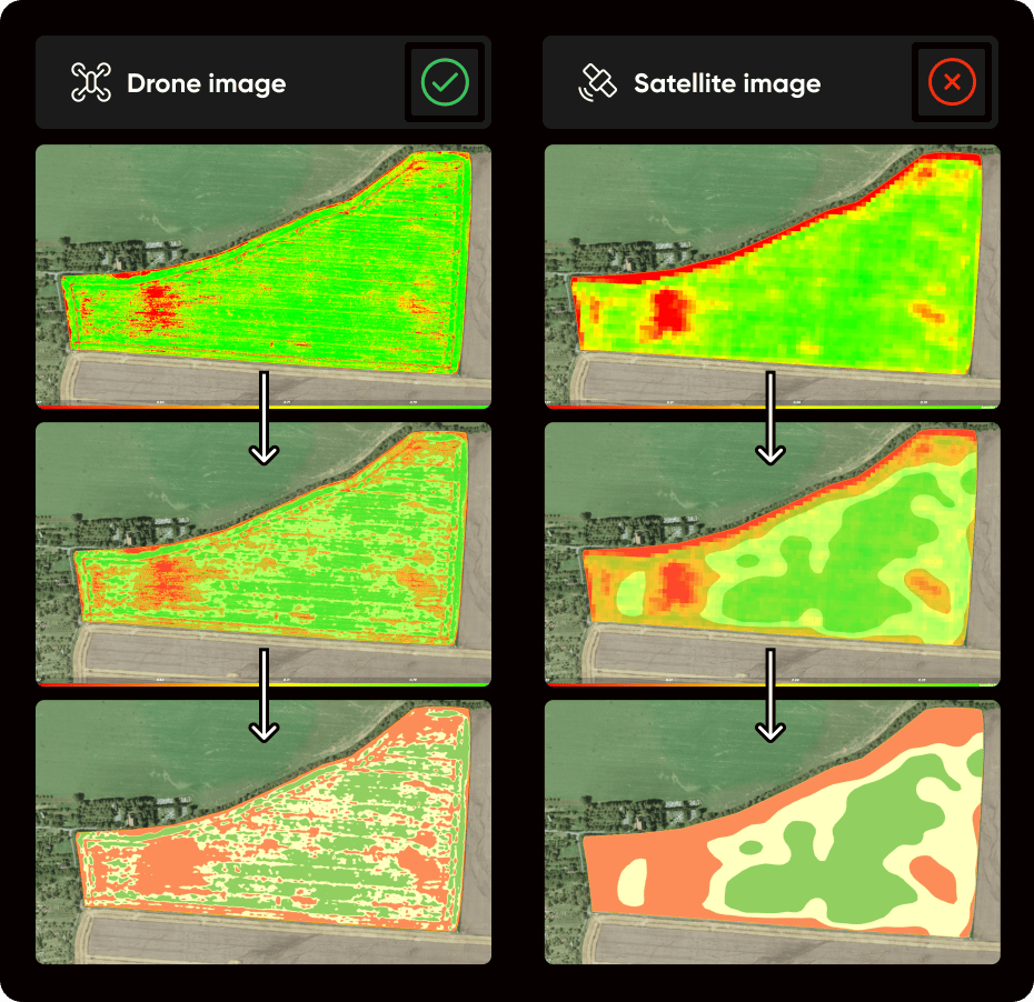
Czech agtech startup Skymaps has launched an advanced drone-based prescription mapping solution through its CultiWise platform, providing farmers with an alternative to traditional satellite imagery.
TXT The system enables precise variable rate applications for fertilizers, fungicides, and growth regulators—even when cloud cover renders satellite images unusable. With the newly introduced CultiWise drone, farmers can generate high-precision crop health maps within hours, achieving up to 20% cost savings and a return on investment within the first season. The feature is available to subscribers of CultiWise’s cloud-based analytics platform, which starts at €5 per hectare, while the CultiWise drone is available from €4,200.
Reliable real-time mapping
Farmers rely on prescription maps to optimize the use of agrochemicals and maximize yield. However, satellite images are often unreliable due to cloud interference, delaying critical decisions.
“With the new CultiWise feature and compact drone, farmers can capture field data instantly and begin spraying the same day,” explains Kornel Cziria, CTO of Skymaps.
The system produces accurate prescription maps that allow sprayers from Amazone, Agrifac, and John Deere to adjust nozzle outputs based on crop conditions. This spot-spraying approach helps optimize agrochemical use by targeting only necessary areas, reducing input costs while improving sustainability.
200 hectares per flight hour
The CultiWise drone can map 200 hectares per flight hour with centimeter-level accuracy, using either multispectral or RGB cameras. These high-resolution images provide detailed field insights, ensuring precise application of crop inputs.
“Drone cameras capture more detail than satellites, eliminating soil interference and offering a clearer assessment of crop health. This is especially useful in early growth stages and for wide-row crops where satellite data can be unreliable,” adds Cziria.
Supporting Sustainable and Cost-Effective Farming
With over 1,000 farm subscribers and local support in 15 countries, CultiWise is making precision farming more accessible. The variable rate application technology aligns with future regulations on pesticide and fertilizer use while helping farmers cut costs and boost productivity.
Join 17,000+ subscribers
Subscribe to our newsletter to stay updated about all the need-to-know content in the agricultural sector, two times a week.


